

To test a trusted steed and a new camera, we lace up our hiking boots and get adventurous.
The Ford Bronco beckoned me, shiny in red against the backdrop of Mt Baker. I was hardly 200 metres away, but I was so exhausted that every stride was a struggle. I had just finished the 6-mile Chain Lakes Loop Trail with an elevation gain of 1,800 feet, and it had completely bushed me. My elevator and Uber-pampered legs just weren’t used to this kind of punishment. My heart was beating in my ears like a jungle drum, my throat was parched, and the sound of my breathing would have put a blacksmith’s bellow to shame.
As I stood catching my breath and glugged down the last ounces of water from my steel canteen, I ran an appreciative eye over the Ford Bronco that was mine for 10 days.
Bronco’s generous ground clearance meant no stress on trails designated ‘4X4 only’.
There is no doubt that it is a very good-looking car, never mind its boxy design. The knobby 17-inch wheels, matte black fenders and imposing stance, thanks to the ground clearance that you can camp under, ensured it turned heads wherever I went with it. And believe me, I went places and racked up 1,400 miles (over 2,240km) in 10 days. Washington State is a part of the Pacific Northwest and is a region of the United States that offers a vast variety of scenic beauty, ranging from evergreen rainforests to alpine mountain vistas that blaze bright with the colours of fall.
The state is divided into two by the spinal Cascade Mountains and is centred on Seattle. To the west are the Puget Sound, peppered with islands, and the Olympic Peninsula, and to the east are the snow-capped mountains speckled with shimmering blue lakes. To the east are also great driving routes, including State Route 542 – the Mt Baker Scenic Byway and State Route 20 – the North Cascades Highway. Sure enough, the lure of twisty tarmac wrapped around snow-capped volcanic mountains and going through conifer forests and past glacial lakes and waterfalls was enough for me to forego fecund rainforests.
 Hydration is a must. Bronco’s cup holders were always occupied.
So, after I picked up the Bronco from Seattle, I headed north on Interstate 5 and then turned east onto SR 542 – the Mt Baker Scenic Byway. My first stop was at the Wake ‘N Bakery in Glacier, 114 miles from Seattle. This cheery coffee shop is a pit stop for booted walkers headed to Artist Point, 24 miles away, at the end of SR 542. Some parka-clad middle-aged people with walking poles in the queue told me they were going to do the Chain Lakes trek. And I said to myself, “This trek must be pretty easy if they’re planning to do it!”
It was a bad judgement call because I’d arrogantly overlooked two facts. Firstly, they were locals, and the Mt Baker area was their neighbourhood playground. Secondly, at 52, I was middle-aged, too!
 Mt Shuksan is reflected in Picture Lake on Highway 542. It stands 9,131 feet tall.
The drive to Artist Point was scenic, and the start of the trailhead itself was stunningly beautiful. Situated in the Mount Baker-Snoqualmie National Forest at 5,140 feet, both Mt Baker and Mt Shuksan overlook this wilderness area. Many hikes fan out from here, and I started along the Chain Lakes Loop.
Since it was early October, the ridge that I was walking along was ablaze with the shrubbery resplendent in red and gold. In 2.5 miles, the trail went past Hayes Lake and Iceberg Lake and then started climbing. It gained almost 800 feet in a mile, and that is where I started to realise my stupidity in gauging my ability based on the group in the coffee shop. The assuaging balm was the stunning views that kept compounding.
 Bagley Lakes on the Chain Lakes hike, which starts at Artist Point at the end of Mt Baker Scenic Byway.
It was a lovely day, and at the 4.5-mile mark, I walked past the deep blue Bagley Lakes fringed by the colours of fall. It was on the final mile that I thought my lungs had shrunk because I was so short of breath. It was no surprise because, in that one mile, the elevation gain was 1,000 feet. The final section comprised a series of steep steps, and for me, that was the stairway from hell. Finally, I staggered up to my Bronco and collapsed into the driving seat. As my breathing steadied and the burn in my legs subsided, I felt a glow of satisfaction because, hard as it was, it had been a very pretty hike with varying light conditions and an array of colours. Thanks to this, I’d been able to experiment with the various modes and settings on my new Sony a6400 camera.
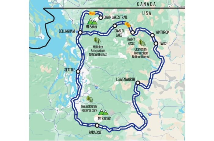
From Artist Point, I drove back 60 miles to the east to Bellingham at the other end of SR 542. The Bronco, for all its height and width and knobby tyres, was very agreeable to drive on this single-lane tarmac highway running along the Nooksack River. Its height and space gave me a sense of roominess, which made my drive all the more satisfying. The wireless Apple CarPlay was glitch-free, the suspension compliant, and the steering precise. This car also featured Ford’s fantastic 10-speed gearbox, which I had previously been acquainted with on the Endeavour in India. Mated to the inline 4-cylinder 2.3-litre engine, it metered seamless torque to the wheels. But, it is certainly a thirsty car because it delivered no more than 16.5mpg, which equates to 7kpl.
The good weather continued the next day. The weather and the time of the year were also factors that made me decide to explore the east of the state rather than the west. In October, the west is rainy and wet, but the east, thanks to the North Cascades Range, lies in the rain shadow area.
I headed south from Bellingham on the I5 and turned east at exit 232 onto SR 20 – the North Cascades Highway.
 Icicle Forest Service Road no. 7600, which is west of Leavenworth, has plenty of trailheads and is vibrant during fall.
This ribbon of tar through the state’s crown jewel – the Cascade Range – winds through some of Washington’s most spectacular mountain scenery, with the Skagit River running alongside. It goes through lofty passes and past little towns that are alpine outposts. It was a very pleasing 70-mile drive from exit 232 to the Thunder Knob Trailhead, from where a 3.4-mile hike along gentle switchbacks leads to a knob above Diablo Lake. The elevation gain here was just 675 feet, and for me – hardened by the hike on the day before – this was a walk in the park. The views of Diablo Lake from the knob were outstanding.
A five-mile drive from Thunder Knob Trailhead brought me to the Ross Lake Overlook. This man-made lake was formed in the 1930s after the building of a dam that still supplies Seattle with a large share of its electricity. Ross Lake stretches north 23 miles into Canada. Beyond Ross Lake, SR 20 climbs higher and gets even wilder. In fact, this road is closed from mid-November to April, as it is snowbound. I was absolutely goggle-eyed at the wheel of the Bronco as I drove from Ross Lake to the 4,855-feet-high Rainy Pass. When I stepped out of the car, there was a definite chill in the air that seemed to whisper, “Winter is coming!”
 A curious chipmunk poses for a picture on the Thunder Knob trail. Maybe it was expecting a treat.
There is a trailhead here for the 6.2 Maple Pass Loop Trail. Trying not to think about how the previous day’s 6-mile hike had knackered me, I set off. On that day, I fared much better, even though the elevation gain was 2,162 feet, and it took me 4.5 hours to complete. The aerial views of the emerald-like Lake Ann made the effort absolutely worth it. Little chipmunks often crossed my path and were surprisingly bold, even posing for photos.
 Patterson Lake near Winthrop is ideal for fishing, swimming and kayaking.
From Rainy Pass, the SR 20 dropped into the broad floor of the Methow Valley, scattered with farms, and 35 miles later, I pulled into Winthrop. A mining town that had seen its underground resources run dry, Winthrop dodged ghost town status in the 1960s when it reinvented itself and took on a Wild West outpost avatar. It sounds artificial, but the town wears this look well. There is a saloon, a bank and a general store that look straight out of a Clint Eastwood movie. Winthrop also has great restaurants and accommodation options, so I stayed a night here.
From Winthrop, I headed south, foraying off the SR 20 often to visit isolated lakes in the Methow Valley. The three lakes that I really liked were Patterson, Davis and Black Pine; all three were serene, secluded and tranquil, and I got good photos of the Bronco reflecting in their still waters.
 No, this pic isn’t an error. Leavenworth has a very Bavarian flair, complete with brews and bratwursts.
I turned off the SR 20 at Twisp and got onto SR 153 and US 97 to roll into Leavenworth – 142 miles away. A part of this route went past the wide and imposing Columbia River. Leavenworth was the second themed town on my route, and for a moment, I thought I was hallucinating. Like how the mining town of Winthrop had a Wild West makeover, the lumber town of Leavenworth underwent a Bavarian makeover in the 1960s after the rerouting of the cross-continental railway made it vulnerable to oblivion. It successfully managed to swap loggers for tourists by reinventing itself as a traditional Romantische Strasse (Romantic Road) village, right down to the brews and the bratwursts. Today, it all looks very Sound of Music, and I strolled through this town, taking in the alpine architecture complete with Gothic fonts and frescoes.
 Morning view of Mt Rainier.
Leavenworth’s Front Street staff at bistros and bars were dressed in traditional German dirndl, and accordionists ambled between shops that were selling cheese and steins. After the mountainous wilderness and Wild West Winthrop, this was a bizarre but endearing experience.
My final destination was Mt Rainier, which, at 14,410 feet, stands 2,000 feet higher than anything in the Pacific Northwest amidst a 368-square-mile national park. Mount Rainier National Park – USA’s fifth national park – is a beacon for adventurers seeking anything from a relaxed stroll to technical hikes. No wonder then that it welcomes 2 million visitors each year. It is especially busy during the summer months of August and September. But people have been coming to Mt Rainier for over 9,000 years. Archaeological findings imply that Native Americans hunted and gathered as well as conducted ceremonial and spiritual activities on the mountain.
 The first frost of the season had already started to appear at Mt Rainier in the first week of October.
When I visited in October, it was the tail-end of the season and hardly crowded. I drove into the park from the Stevens Canyon Entrance in the southeast, an hour before dawn. That was one of my most thrilling drives since the road was narrow and curvy, and tall Douglas-fir trees stood as sentinels along the side of the road. Many of these trees were easily over 700 years old. The bright headlights of the Bronco set on the auto dipper mode gave me good visibility and inspired confidence. Deer darted twice across the road, and the good throw of the headlights gave me enough time to dab the brakes and bleed off speed.
 Reflection Lakes in Mt Rainier National Park at dawn. It attracts photographers, especially on clear days.
I arrived at Reflection Lakes just as dawn was breaking, and the sight that greeted me was ethereal. The lake was so still that it reflected Mt Rainier, which towered above it. Wisps of mist were rising from the surface of the water, and the top of the mountain and the conifers at its base were glowing with the rays of the rising sun. It was a photographer’s delight. As the light grew stronger, I drove to Paradise, which was 3 miles further from the Lakes.
 A deer grazes as hikers start off on the Skyline Loop.
In the 1880s, Martha Longmire, the daughter of park pioneer James Longmire, exclaimed, “What a paradise!” when she first visited this area, which sits 5,400-feet-high on the south side of Mount Rainier. Lo and behold, the area had a name! It is a fitting one at that because it features lofty flower meadows backed by dramatic Rainier views. Birds and butterflies flutter through, and deer daintily graze.
It was a blue-sky day when I was there, and the colours of fall were peaking and blazing at full saturation in the soft light of early morning.
 The flower meadows of Paradise turn vibrant during fall.
By this time, 6-mile hikes were no longer a big deal for me, and I spent that morning walking the 5.8-mile Skyline Loop. It took me four hours to complete because the views were so stunning that I often stopped to drink them in and tried to capture the vibrant visual vistas on my camera. The trail was uneven and certainly hard on the legs, but the views made this ramble well worth the effort.
Two days prior, on October 8, Tuesday, when I was in Winthrop, an eruption of charged particles or ‘plasma’ had burst from the sun and started speeding towards our planet at 2.9 million mph. Even at this speed, the plasma took two days to cover the 93 million miles between the Sun and the Earth and struck the Earth’s magnetosphere on Thursday, October 10. The result was a gorgeous display of the Northern Lights across the world.
 The Northern Lights play out over Paradise.
Photographers whom I met on the Skyline Loop had told me about this solar phenomenon. So, at 10pm, I headed into the park again. It was chillingly cold, and as there was no artificial light for miles around, it was pitch dark. The sky was studded with stars, and I spent the entire night huddled in my sleeping bag in the Ford. The Bronco’s heated seats were a real comfort that night. But it was a night well spent because I did get to see the Northern Lights flashing in all their glory over Mount Rainier. It was a fitting finale to my road trip.
I remember sipping hot coffee from my flask while watching shooting stars streak across the sky and thinking about how the next day, I would start to make my way back to Seattle, where I would plug back into the urban circuit. But at that moment, with my Bronco in the quiet solitude of Paradise, the humdrum of the city seemed as distant as the stars twinkling in the heavens above.
A guide to good leg stretchers
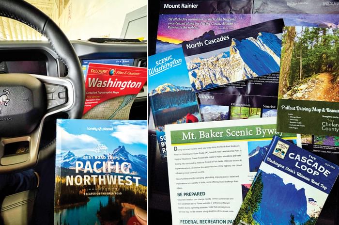
Not surprisingly, given the terrain, the routes I drove offer a variety of hiking and walking opportunities. These trails range from hard day-long walks to easy half-an-hour strolls. There are so many trails that deciding which ones to attempt can become a bit overwhelming. Information Centres and Visitor Centres on these routes are fantastic resources, offering maps, brochures and information. The centres are manned by helpful and knowledgeable park or forest rangers, and if you tell them the time that you have on hand and your hiking capability, they will suggest hikes and trails en route. Ask them to mark these out on the free maps available at these centres.
Even though I research my route and activities in advance, I always make it a point to stop at these centres, and they have always enhanced my road trips.
This feature was published in Autocar India’s December 2024 issue.
Also see:
Road tripping in the Defender Octa across England’s Lake District
Source link